Upper Poplar Creek Watershed Drainage Improvement Phases I, II, and III
Updated: 2/9/24
Created: 9/28/23
CURRENT STATUS
Phase I - Upper Cartecay Drive from Sylvan Circle "Bamboo Lot" to Ellijay, Coosawattee and Cartecay Intersection. In Final Design
-
Phase II - Design Proposals Due 1/19/24.
-
Ellijay, Coosawattee, and Cartecay Intersection Drainage System Design
-
Evaluation and selection of design team: 2/2/24.
-
-
Phase III - Design Proposals Due 1/19/24.
-
East side of Ellijay Dr: Install curb & gutter and closed conveyance system (piped)
-
2523 Ellijay Drive to end, south of Cartecay Drive
-
Evaluation and selection of design team: 2/2/24.
-
Professional Engineering Design Services Firm - Phase I
![]()
![]()

POND DESIGN TEAM NEXT MILESTONE: 60% DESIGN DOCUMENTS, OPTION 3
Completed: Final Concept Design with Concept Level Opinion of Cost
- All Scenarios (Option 1):
- Disconnect Sylvan and Star Drive Drainage System from the privately constructed system behind homes on Upper Cartecay Dr.
- Leave existing privately constructed system behind homes on Upper Cartecay Dr to serve only those lots
- Option 2: Install a piped drainage system from the Sylvan Dr "Bamboo Lot" south to existing perennial stream
- Option 3: Install an open, shallow, and wide swale from the Sylvan Dr "Bamboo Lot" south to existing perennial stream.
SCHEDULE:
Field Work: Phase I: Started October 2nd - Completed week of October 2nd.
Design Phases:
Phase I
-
Concept Design: Complete December 2023
-
Final Design: February 2024
Phases II and III:
-
Selection of Design Team: February 2024
-
Field Work Complete: April 2024
-
Final Design Complete: September 2024
Permitting: Duration: Estimated 3 - 5 months
Construction: Duration: TBD, Estimated 3 - 5 months, dependent upon details of selected Scope of Work
PLEASE NOTE: Field contractors providing support services will not have full or current project information and could provide inaccurate info. They've been instructed to refer you to this Project Information Page.
Please confirm any information you are provided with the Project Information site or the City's Project Manager
Please be aware that there will be survey and geotechnical crews on and around the area in the coming weeks. They should identify themselves as Contractors for Public Works. Survey work started October 2nd and has been substantially completed. Follow up field work may be intermittent in the following weeks.
Our selected engineering design firm will be collecting data and making frequent site visits as they develop the Conceptual Design for Upper Poplar Creek Watershed Drainage Improvement Project - Phase 1.
Project Scope and Location
Background
The Upper Poplar Creek Watershed is comprised of over 235 acres that drain though a 48” corrugated metal pipe (CMP) culvert at the intersection of Cartecay Drive, Coosawattee Drive, and Ellijay Drive. This intersection is prone to frequent short-term duration inundation. In late 2022 to mid-2023 Dewberry Engineers completed a comprehensive PCSWMM hydrology and hydraulics model and study of this watershed. This study resulted in the conceptual development of the Upper Poplar Creek Watershed Drainage Improvement Project that will ameliorate these occurrences. The project is divided into three separate phases, with Phase II as the linchpin. The desired Level of Service (LOS) at the intersection, elimination of intersection inundation up to the 10-year, 24-hour storm, will only be achieved though completion of all three phases.
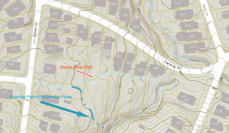
Phase I of the project addresses flows generated in the Sylvan Circle / Star Drive area. Historically, runoff from this area collected and flowed to a location of a former creek that was historically mapped as a perennial stream by DeKalb County. At various points in the past, grading associated with new home construction filled in this former stream and its overbank areas and replaced it with an 18” underground conveyance system. Since that time, the residents along this former stream experience significant overland flow from runoff that cannot be conveyed through this undersized collection and conveyance system. The volume and energy of this runoff damages landscaping improvements and threatens to inundate ground-level structures along the path of the former creek. This area runs along most of the length of Cartecay Dr between Sylvan Cir and the Cartecay, Ellijay, and Coosawattee intersection and is designated as Phase I of the Upper Poplar Creek Watershed Improvement Project.
At the conclusion of the Concept Design Phase, Public Works and Pond intend to hold a public meeting to inform the residents of the proposed plan.
Phase II consists of drainage improvements and utility relocations at the intersection of Ellijay Drive, Coosawattee Drive, and Cartecay Drive. The work in this phase impacts (lowers) water levels to the greatest extent. When coupled with Phase III, the desired LOS is met. Phase III collects most runoff from Ellijay Drive and conveys it under the interection with a point of discharge on the south side of Cartecay Drive.
Points of Contact (POC):
Tom Roberts, PE, Deputy Director Public Works, Tom.Roberts@BrookhavenGA.gov, 404.637.0528
Steve Osborn, PE, Municipal Projects Manager, Steve.Osborn@BrookhavenGA.gov, 404.637.0520